


 Training Overview
See a summary of all our training options one page. All courses are currently available online.
 Group Training
The leader in business continuity education and certification across many industries, DRI International offers team training designed to fit the needs of every organization, from private corporations to the public sector and everywhere in-between.
 Higher Education
DRI International offers colleges and universities the opportunity to familiarize their students with information on business continuity professions and certifications recognized by private and public sector organizations around the world.
Certification Overview
Certification is a two-part process; verification of knowledge and confirmation of experience.
 Value of Certification
A DRI International certification is the most widely recognized and respected business continuity certification in the world. DRI only certifies professionals that have demonstrated both knowledge and experience in the business continuity and/or disaster recovery profession.
Learn more about how to unlock your DRI digital badge and display your DRI certification to enhance your online professional profile today.
 Maintain Certification
Maintaining your DRI International certification carries two requirements; an annual maintenance fee as well as Continuing Education Activity Points (CEAP).

Be a part of the premier business continuity conference. Join us at DRI2025 in Las Vegas, Feb. 2-5, 2025. Check back for more information.
 Meet DRI
We speak at numerous industry events around the globe and engage with our community in a variety of ways. Find out where you can meet DRI.
 Thought Leadership
Through committees and other initiatives, we publish research and insights about the profession. Explore our library and other resources.
 Webinars
DRI International webinars cover vital resilience issues, engaging and informing professionals in the field. See what's coming up next and view previously broadcast presentations here.
 Hiring Guide
Learn how to hire the right business continuity professionals that will enable your organization to withstand any crisis and come through even stronger with the DRI Hiring Guide. Download now.
 What is Business Continuity Management (BCM)?
BCM is a holistic management process that identifies potential threats to an organization and the impacts to business operations those threats, if realized, might cause, and which provides a framework for building organizational resilience.
 DRI in the News
We reach out and engage as many audiences as possible using broad media coverage to provide a forum for discussion. We serve as a trusted resource to other professions and the general public.

FEMA Launches Full National Risk Index for Emergency Assessment and Planning
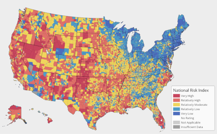
After a preliminary rollout, FEMA has unveiled its fully operational tool to help organizations and communities analyze their biggest risks to help them better prepare.
FEMA’s U.S. National Risk Index was initially introduced in Nov. 2020 on a limited basis. Now it has launched the full application for users. It’s an online mapping resource that identifies communities most at risk to 18 natural hazards:
Users can discover hazard risk metrics, data about expected annual losses, social vulnerability, and their community’s resilience levels, via interactive web maps and other visualization tools. It’s expected provide ongoing assistance in updating emergency operations and hazard mitigation plans, identifying areas in need of better risk assessments, encouraging local risk communications, and much more.